Lesson 94
25 November 1998
2.9 hours
First Flight to First Flight Airport
This is my birthday (just yesterday someone remarked that it's the day
I become eligible for Social Security--Jesus!), so what better place to
fly to than Kill Devil Hills, where Wilbur and Orville Wright flew their
machine for the first time.
 I've
been thinking about this trip for a long time, and the longer I thought,
the more daunting it became in my mind. Across water. Short
runway. Stiff winds. I'd heard that First Flight Ariport--FFA--was
hard to locate and tricky to land at. Trees at one end and a power line
at the other end. People said things about gravel and sand, and I'd seen
some satellite photos (right--north is up--thanks to Terry Henert!) that
made it look like a wasteland But the weather was going to be beautiful
this morning, so last night I plotted the course on my Washington sectional,
picked out some checkpoints, and made up a nav log.
I've
been thinking about this trip for a long time, and the longer I thought,
the more daunting it became in my mind. Across water. Short
runway. Stiff winds. I'd heard that First Flight Ariport--FFA--was
hard to locate and tricky to land at. Trees at one end and a power line
at the other end. People said things about gravel and sand, and I'd seen
some satellite photos (right--north is up--thanks to Terry Henert!) that
made it look like a wasteland But the weather was going to be beautiful
this morning, so last night I plotted the course on my Washington sectional,
picked out some checkpoints, and made up a nav log.
Although I wanted to navigate by pilotage--looking at things on the
ground--I also entered the route into a nifty little Palm Pilot program
called "Flying Pilot" that uses data from a GPS to depict where you are
on your course and to display airports, navaids, cities, and any waypoints
you give it. If you enter the wind direction and velocity, it also
calculates your heading; and it displays your true ground speed, time to
the next point, and some other things to make navigation easy.
First thing this morning I phoned WX-BRIEF to get the weather.
The briefer said, "You're going to hate this" and gave me the beautiful-VFR-weather
news. Clear sky, excellent visibility, moderate winds. Cirrus
moving in at 4500 feet later in the afternoon, but otherwise no change
in conditions until after dark. Okay, so I filed my flight plan for
both directions and headed for the airport.
I had scheduled N75709 from 10 to 3, enough time for a 122 nm flight
at about 100 knots, but it wasn't going to give me a lot of time on the
ground, so I wasn't exactly happy to find that it had just come in from
a two hour flight and needed fuel. But no problem; I requested fuel
while waiting for the dispatch. Several things seemed to be happening
at once in the terminal, and it took 20 minutes to get the dispatch.
Just as I was heading out to preflight 709, Becky showed up with a little
home-made placard for me to stick over the turn indicator--she said it
didn't work. Well, that wasn't quite what I wanted to hear, but it
wouldn't ground the airplane. Out on the ramp, I requested fuel again.
I preflighted. I requested fuel. I cooled my heels. I
requested fuel again, and finally the line guy remembered and drove up.
It was about 10:45 before I got the engine started. During the runup
I noticed that it ran rough on the left mag. It didn't go away, so
I stood harder on the brakes and ran it at full throttle for half a minute.
That cleared the plugs, so I took off. But just to be sure that everything
was working right--and that I was tuned into the airplane--I did a touch
and go before climbing to 2500 feet and heading southeast.
I hit all of my checkpoints right on the minute and the GPS showed me
right on course, too. The course took me past Wakefield, Suffolk,
and Lake Drummond, then between Elizabeth City Airport and Currituck County
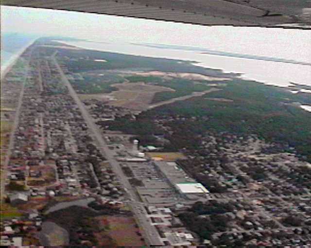
Airport. By then I could see the Albemarle Sound ahead and soon I
was over the water, crossing directly over the middle of the five mile
long bridge to the Outer Banks.
FFA is unattended, so as I approached the bridge I tuned in the Dare
County Airport AWOS to get the altimeter and wind. (Dare County is 12 nm
southwest of FFA.) Wind 110 at twelve--rats! FFA's runway is
2/20, so 110 is almost perpendicular to it. Well, I'll go see what
the windsock looks like at FFA.
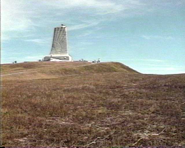
Contrary to what I'd been told, the runway was fairly easy to find because
I knew it was right beside the Wright Brothers monument, which is on top
of a perfectly round hill with a circular road around the base of the hill.
Finding the windsock, on the other hand, was a little harder. I finally
spotted it several hundred yards to the north, on top of a second round
hill.
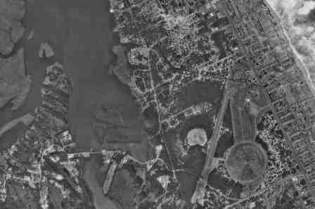
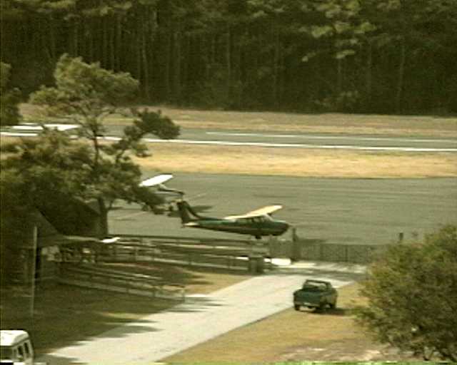
Here's a blurry lo-res camcorder frame showing the airport and the Wright
Brothers Memorial. The view is to the south. The runway is
the diagonal line through the dark area, with the 20 end closer to the
camera. The tan-ish area to the east of the runway, looking something
like a keyhole, is the memorial grounds. The eye of the keyhole is
a round hill with a tall monument on top, and the historic first flight
took place on the lower part of the keyhole. You can just see a lighter
line down the middle of it marking the actual flight line. The lighter-colored
area to the west of the runway is another round hill--foreshorteded to
a line here--on top of which the windsock is located, well above the treetops.
Aw, geez, the widnsock is blowing straight out--probably 15 knots--and
at exactly a right angle to the runway. Nobody talking on the CTAF
frequency. What do I do now?
I circled the airport a second time at 1000 feet, thinking it over,
and decided to take runway 2 because runway 20 has a right-hand approach--and
even then it's right over houses. The approach to the 2 end, on the
other hand, is mostly over the water, and the power line isn't a high one.
There's still the crosswind, but I can see that the runway is sheltered
on both sides by 50-foot trees, so it may not be a problem. I turned
final, crabbing over the power line, and straightened out and slipped over
the road and to the threshold. Good speed, good glide angle.
The wind is gone, full flaps, throttle to idle, and down neatly.
Back-taxied to the ramp--which, like the runway, turned out to have been
recently paved--and parked. Piece of cake, old top. Brand new
tiedowns, but no ropes. (Bring your own. Parking limited to
24 hours.)
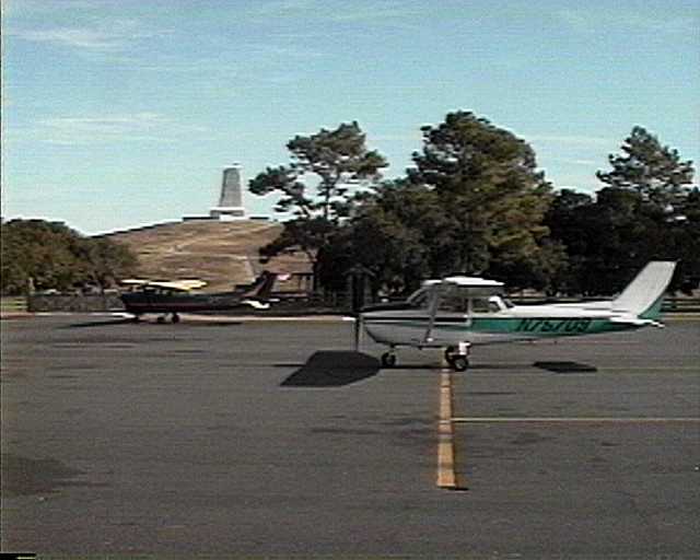
Found the Porta-Potty, then hiked up the hill to the monument.
Looking back at the ramp from the monument. Runway 2 is beyond.
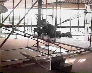
In the museum--a reconstruction of the Flyer.
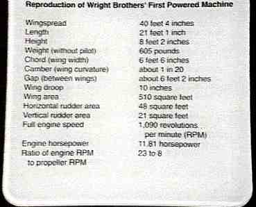
The POH--Section 7, Airplane & Systems Descriptions:
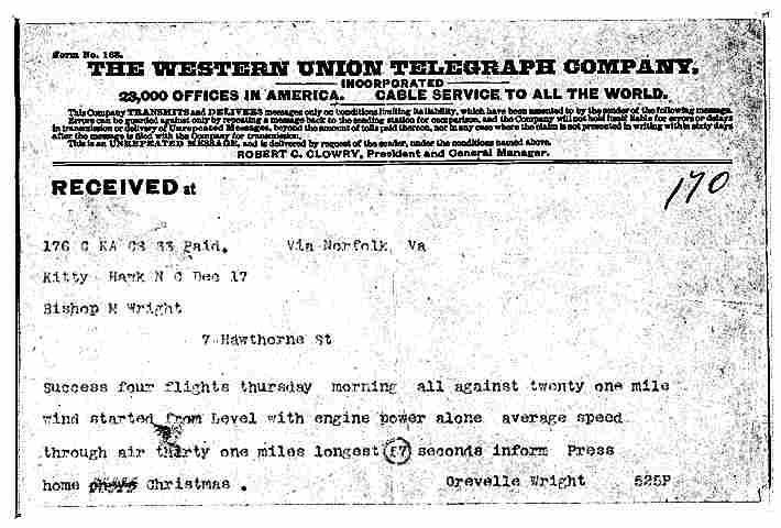
This is THE telegram, courtesy of the Library
of Congress. In transmission, 59 seconds was changed to 57 and
Orville's name got misspelled. Or mispelled. Mispeled?
I had only an hour on the ground, so I gobbled down two granola bars
while walking from the monument to the museum. Bought some postcards
and books. Encountered a tourist who warned me not to walk in the
grass because of the prickly pear cactus and showed me her shoe, which
had been attacked by three of the little buggers. Back to the plane.
Flew home. Arrived ten minutes late. (Didn't care. Had a grand
day)
Back
to "Learning Flying"
My home page.