Seaplane Ops at the Taj Mahouse 


LOCATION

The Taj Mahouse is in Shangri-La-di-da.  That's in Virginia, on Jordan Point in the James River, east of Hopewell and southeast of the Route 106/156 drawbridge.  X marks the spot:
 
seaplane ops


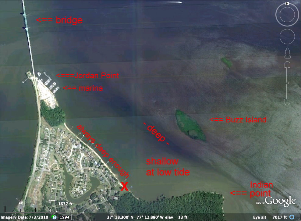
Coordinates:
(all formats indicate the wrong house in GoogleMaps)
N37º 18' 17.77",   W77º 12' 53.29"
37º 18.300',          -77º 12.880'
37.305000,           -77.215000
Radio frequency: 123.45
Phone: 804-543-7110
Street address: 10463 Jordan Parkway, Hopewell, VA 23860.  (Google it for an aerial view of the river and the correct house.)
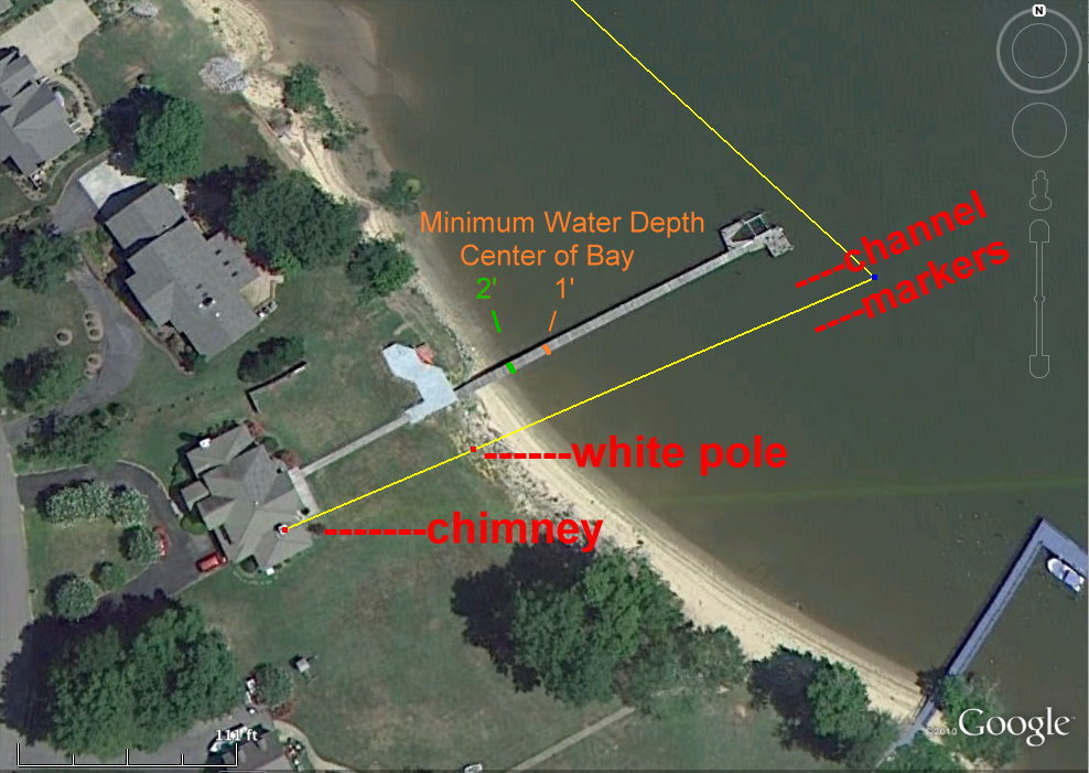


The water is fresh, but there is a 3 foot tide.

When the tide is medium or higher, there is plenty of water everywhere for seaplane ops.  You can land anywhere, in any direction. 

(What follows may look complicated at first, but it's actually quite simple.)

At very low tide, the center of our little bay gets shallow.  During rare extremely low tides, that part of the bay becomes a mud flat--but it's still safe to land and take off by going around the edges.  (See photo below.)


seaplane ops


The colors suggest water depth.  The blue area ("- deep -") is always at least 15 feet deep, even at low tide.  The greenish "shallow at low tide" area can be too shallow at low tide, and occasionally--rarely--it even becomes a mud flat.  That's when I go along the line of piers, where it's always deep enough.


VIDEO--seeing is believing

Here's a cockpit video of taxiing onto the beach at low tide.  (Opens in a new window.)  http://www.youtube.com/watch?v=aAwBC6R-RvY&list=UUUZxvBxevBs9vms_0QlBRqg&index=2&feature=plcp


TIDE PREDICTION TABLES


If you're planning ahead (or merely curious) check the tide tables for Jordan Point:

     Here's an interesting tide table.  (Opens in a new window.)

     And another interesting tide table.  (Ditto.)


NOTE: These are predictions.  Actual tide height is strongly influenced by wind and magic.


ACTUAL TIDE HEIGHT


Here's a simple method for gauging the water depth.  (No magic required.)

Fly over our place and look for 2 stripes across the pier. 


WATER LINE AT
TIDE state
DEPTH of shallowest area in center of bay
GREEN     IN-shore (west) stripe medium
at least 2 feet deep everywhere.
ORANGE  OFF-shore (east) stripe low at least 1 foot deep.


In the photo above, the water line is INshore (west) of the green stripe.  No problem!  It's deep enough everywhere for SeaReys and Lakes.  For deeper draft seaplanes you'd have to decide for yourself.

When the water line is between the stripes, the minimum depth in the center of the bay is between 1 and 2 feet.  That's deep enough for step-taxiing in my SeaRey, but might be shallow in places for displacement mode.

When the water line is OFFshore (east) of the orange stripe, avoid the shallow area.  Taxi around the north end of the shallows and keep close to the piers.

My SeaRey draws about 0.5 foot on the step and 1.5 feet in displacement mode with the gear up.  Most of the time I can take off and land even in the center of the bay.

If you're not sure, just stay out of the middle. 


VERY LOW TIDE

The bottom is soft mud, so even if you went aground, it wouldn't do any harm to the airplane.  The mud is slippery, so getting stuck isn't likely, but if it happened, the tide would soon float you free.

Even at very low tide there is always enough water just off the piers, about 100 feet out from them.  When taxiing in displacement mode at
extremely low water--it's very rare--I turn toward shore near the marina, or in line with the northern-most pier, and keep in close to the piers all the way to our pier.

I've never seen less than 3 feet of water along the piers, even when the "shallow" area is exposed mud flat.  And that happens only 3 or 4 times a year.


ONTO THE BEACH

At medium tide or higher, you can just taxi in to the beach anywhere.  Lower the gear before passing the end of the pier.  The bottom is soft and flat, so be ready to add plenty of power as soon as the wheels touch.  LOTS of power.

If you have a nosewheel, it might be better to leave the gear up.  If in doubt, leave it up.  Just taxi in as far as you can and tie to a tree or a tiedown.  You might prefer to turn the airplane around and tail it in.  There's usually a coil or two of rope on the beach or the pier if your line isn't long enough.


CHANNEL

Our pier is about 200 feet long.  For the outer 100 feet, the bottom is very sticky mud.  The inner 100 feet is firm mud, firm enough to taxi on.  The beach is sandy.

I've dredged a channel through the sticky part that lets my SeaRey taxi in and out at any tide height.  My SeaRey draws about 1.5 feet with the gear up and about 2 feet with the gear down.   


At medium tide or lower you'll see 2 pairs of poles with green cross-shaped tops marking the channel.  Their tops are 3 feet above the bottom.

At quite low tide you may see an outer (third) pair of shorter poles marking the entrance to the channel.

If you see 2 rows of small poles between large green cross-top poles, the water is less than 2 feet deep there.  Stay between the lines of poles and use plenty of power.


If you see no poles at all, the tide is high and you can go anywhere.


seaplane
        ops


Alternate method: You may see a white pole on the grassy bank.  At medium or low tide, keep the white pole lined up with the left white chimney until you're at least halfway in from the end of the pier.


SANDY BEACH

The river is always changing the beach, and sometimes the sand gets soft in places.  If your wheels get bogged down--no problem!  There are several 4' x 8' plastic lattice mats that will get you moving again.  Just slide one in front of the bogged-down wheel and taxi onto it.


ANCHORING

There's a white mooring buoy between our pier and the southern-most pier, but about 100 feet farther out, where the water is always deep enough.  You can tie up to it, or you can anchor anywhere near the buoy (but clear of any airplane tied to it).  You'll want to stay on the "deep enough" line, about 100 feet out from the line of piers, but not more than 200 feet out from them.  We'll pick you up with the (ahem!) Large Marge Party Barge & Self-propelled Seaplane Tender.


EAGLES & OSPREYS
A pair of ospreys have been nesting on our pier in spring and early summer.  A pair of eagles has a nest in a tall tree near the east end of Indian Point--the little point to the southeast of our place. It's not an official sanctuary, but I try not to fly low directly above the nest.  There never seems to be any conflict if I stay offshore, or approach to land over the trees close to our house.


_________________________
Page last modified: 2013-09-11


Don Maxwell's home page.